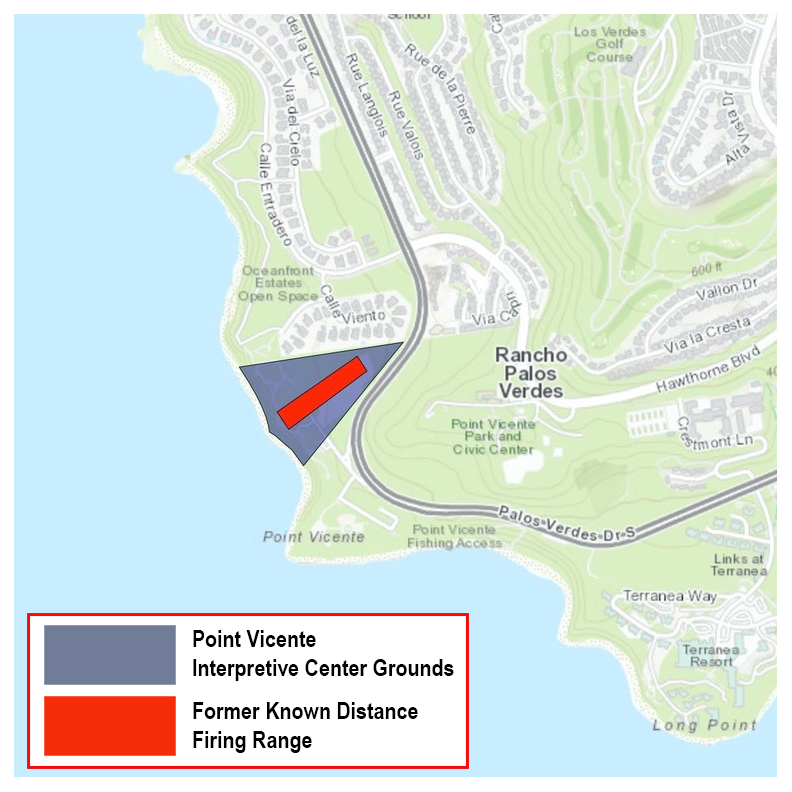
The Pt. Vicente Soil Contamination project is located on the
Point Vicente Interpretive Center (PVIC) property which consists of 26-acres
located in Rancho Palos Verdes, California, in Los Angeles County. The site is
bounded on the south by the historic Point Vicente Lighthouse and the Coast
Guard Reservation; on the west by the Pacific Ocean and sea cliffs; on the
north by a storm drain and the Oceanfront Estates community; and on the east by
Palos Verdes Drive West.
A 26-acre, triangular-shaped area in the lower section of
what was identified as Tract No. 8, bordering the Pacific Ocean, was used by
the U. S. Army as a rifle range. The rifle range was developed as an Army Known
Distance Rifle Range with firing lines at 27.7-, 100-, 200-, and
300-yards. The Army KD Rifle Range was used for small arms target practice and
qualifying by active and reserve Army units stationed at Fort MacArthur and by
units of the California National Guard.
The Army KD Rifle Range was deactivated in 1974, and the
site was leased to Los Angeles County, which made no improvements. Before the
term of the lease expired in 1979, the U.S. Army transferred the site to Los
Angeles County by quitclaim deed. Los Angeles County subsequently leased the
site to the City of Rancho Palos Verdes. Los Angeles County conveyed the
property to the City of Rancho Palos Verdes by quitclaim deed on 16 December
2003.
After opening in 1984, the PVIC became a well-known
educational and recreational resource in Southern California. By 1998, city
officials decided to undertake a comprehensive expansion program that would add
7,000-square feet to the exhibit building. Excavation for the expansion led to
the discovery of lead-contaminated soil in late July 1999. Due to concerns for
public health, the PVIC was closed to the public in August 1999.
The PVIC remained closed throughout 2002, during which time
the U.S. Army Corps of Engineers Los Angeles District, managed the planning and
remediation of the lead-contaminated soil. Hot spots of lead-contaminated soil
were removed and replaced with clean soil. Outside the area of the hot spots
the upper 1-foot of soil was replaced with clean soil.
The PVIC was reopened on a limited basis in December 2002,
when the removal of lead contaminated soil was completed. The expansion of the
PVIC exhibit building resumed following the cleanup. The expansion was
completed in July 2006, and the PVIC was fully reopened to the public.
In March 2024, the Corps completed a Remedial Investigation
to characterize Site conditions, determine the current nature and extent of
lead contamination following the 2002 Removal Action, and perform a human
health risk assessment and baseline ecological risk assessment based on current
and reasonably anticipated future land use scenarios. Based on the Remedial
Investigation’s finding of no unacceptable risk to human health or the
environment from lead, the Corps is proposing to take No Further Action at the
Site.
In November 2024, the Corps completed a Proposed Plan to
document the proposed No Further Action decision for the project. Community outreach for the Proposed Plan
included 31-day public comment period from Aug. 31 to Oct. 2, 2024 as well
as a public meeting held on 10 September 2024 at the PVIC. No public comments
were received during the public comment period or at the public meeting.
In September 2025, the Corps finalized a Record of Decision to document
the decision for No Further Action for the project based on the Remedial
Investigation’s finding of no unacceptable risk to human health or the
environment from lead under current and reasonably anticipated future land use
scenarios.