US Army Corps of Engineers
Los Angeles District Website

Photos

Oceanside Harbor, California


General Information

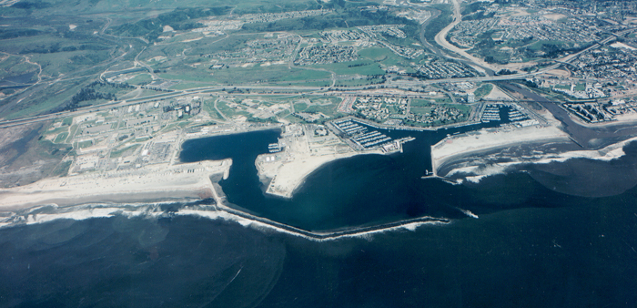
The Oceanside Harbor/Camp Pendleton Harbor complex is located north of the city of Oceanside and just south of Camp Pendleton Marine Corps Base, 35 miles north of San Diego, in San Diego County, California. The harbor's breakwater and south jetty form an entrance channel. The entrance channel splits to form the Oceanside Channel, which leads to a small craft harbor, and the Del Mar Channel, which leads to Camp Pendleton's Del Mar Boat Basin. Camp Pendleton is a large U.S. Marine Corps facility that dominates the surrounding area.

The U.S. Army Corps of Engineers Los Angeles District dredges this entrance channels on annual basis in order to maintain the federally authorized depth necessary to accommodate the military, commercial and private vessels that use the harbors. The Corps works with Camp Pendleton and the project's local sponsor, the City of Oceanside, to identify the most efficient and cost-effective way to complete the project.

Material dredged from the entrance channels is typically beach-quality sand that is used to re-nourish Oceanside's shoreline from south of the San Luis Rey River discharge to points south to the Oceanside pier and beyond, depending on the quantity dredged each year. This beneficial re-use improves the project's cost effectiveness and provides an economically acceptable for the City of Oceanside to widen its beach, increasing its recreational value and adding protection for business and residences adjacent to the beach.


FAQ

Collapse All Expand All
Strategic in-channel vegetation removal will be accomplished in Reach 2-a in the vicinity of the Riverside Drive and Zoo Bridge. Temporary protective barriers are being placed along the river’s edge from near Griffith Park to Elysian Valley, including Glendale Narrows. These barriers are used to restore capacity of the channel to keep the LA River in its banks. These areas have been identified in our evaluation as the highest risk areas.
The vegetation removal contract was awarded Jan. 8 to BJD Services of Santa Clarita, California, and the temporary barrier placement contract was awarded Jan. 9 to JF Engineering of Pomona, California. Work is expected to begin the week of Jan. 11. The Corps continues to ensure that the standards of environmental, economic and property stewardship are practiced and those rights are protected and respected. Temporary protective barriers installation should be complete within a month, while in-channel vegetation removal will continue until mid-February.
No. The IRRMs address the most critical areas to restore channel capacity, with an emphasis on addressing residential and commercial area flood risk. Other areas along the segment of the river from Griffith Park through Elysian Valley remain susceptible to flooding under larger events. In addition, localized flooding from interior drainage systems, streets, etc can occur, unrelated to breakouts from the river channel.
The Corps knows the importance of native habitat to its ongoing LA River ecosystem restoration partnership with the City and the County and will take strides to remove only non-native vegetation in most of the affected area; however some native species will need to be removed in the interest of public safety. This will happen in an area just upstream and downstream of the Riverside Drive and the Zoo Bridge.
No. The proposed ecosystem restoration project has not been authorized by Congress and is not related to the decreased conveyance capacity in the channel. The restoration features in that plan would include planting in areas where the channel would be widened and in areas outside the channel.
All IRRMs are subject to environmental evaluation and compliance. Removal of vegetation is needed to restore some conveyance capacity in the river channel. Vegetation removal is mainly focused on removal of non-native, invasive vegetation such as arundo that clogs channel capacity. The exception is in Reach 2A, where both native and non-native vegetation has reduced channel capacity and where vegetation in the immediate area of the Riverside Drive/Victory Boulevard Bridge creates a severe channel constriction. In this area, approximately 1.2 acres of native vegetation would be removed. This is a minimal amount of native vegetation removal to address the immediate risk.
The channel was built to convey 40,000 cfs; vegetation removal restores that capacity without the need for temporary protective barriers. (Channel capacity in this area currently 25,800 cfs.)
The placement of the temporary protective barriers will take up to 4’ of the bike path in places. In consultation with officials and safety experts, the bike path will need to be closed for public safety. Officials are looking at potential detours for cyclists to use.
The temporary protective barriers will be removed soon after the end of the flood season, which is typically mid-April. At that time, we’ll confirm the forecast before removal, which should be completed within two months.
Corps experts routinely evaluate flood risk management capabilities of the LA River and as part of their winter storm inspections. In light of the likelihood of greater than average rainfall associated with El Nino weather conditions, further scrutiny of Corps structures and facilities was undertaken.  The evaluation has indicated unacceptable levels of risk given anticipated rain fall events lasting through this spring. To address those elevated levels of risk, the Corps is implementing risk reduction measures which include placement of temporary protective barriers along the top of the riverbank.
It's a matter of channel capacity. The original design capacity for that reach of the LA River was 78,000 cfs (cubic feet per second). Our evaluation showed the existing capacity averaging roughly 40,000 cfs due to vegetation growth. With the placement of the temporary protective barriers we will restore capacity to an average of roughly 60,000 cfs.
Not even close! During last week's storm events, we observed water levels reaching only about one-third of the channel capacity.
The barriers we received come in two heights, 3 feet high and 4 feet high. They are 3 X 3, but come in sections of 15 linear feet (five 3 X 3 baskets connected together).
Height varies with width in order to achieve the design flow conveyance capacity.
They are 3 X 3, but come in sections of 15 linear feet (five 3 X 3 baskets connected together). They are filled with earthen material and, in our case, will be filled with sand.
Each 3 X 3 X 3 barrier holds approximately 27 cubic feet of material. The 3 X 3 X 4 barrier holds approximately 36 cubic feet.
The barrier will be placed immediately adjacent to the edge of the channel so as to minimize its footprint and impacts to the maintenance road.
Mostly one bank, but there are a few spots where barriers will be placed on both banks.
It begins in the north roughly at W. Broadway and continues roughly to the CA2 freeway.
Temporary protective barrier installation should be complete within a month.
Our district has not used them before in Southern California, but the Corps has used them in the Midwest, in places like Fargo, N.D., and various locations along the Mississippi River.
Corps experts routinely evaluate flood risk management capabilities of the LA River and as part of their winter storm inspections. In light of the likelihood of greater than average rainfall associated with El Nino weather conditions, further scrutiny of Corps structures and facilities was undertaken.  The evaluation has indicated unacceptable levels of risk given anticipated rain fall events lasting through this spring. To address those elevated levels of risk, the Corps is implementing risk reduction measures starting next week which include removal of some in-channel vegetation, placement of temporary protective barriers along the top of the riverbank, and repair of damaged sideslopes and flapgates. In addition, when excessive rainfall is anticipated, the U. S. Army Corps of Engineers establishes a 24-hour watch in its Reservoir Operations Center to monitor rain forecasts, river flows and the amount of water temporarily stored in our basins. Coordination with our partners includes frequent notification of our project conditions and the local entities use this information to evaluate and implement safety recommendations.  Onsite monitoring is also triggered when channel capacities reach 50%.
The Corps uses the flood forecasts from the National Weather Service for conducting flood fight operations. District hydrologic and hydraulic engineers work with the NWS to obtain and analyze data used in the forecasts.  Coordination with NWS is an integral part of the district’s flood fight planning. (The NWS is the sole federal agency responsible for providing flood predictions.)
The Reservoir Operations Center is a 24-hour watch in its Reservoir Operations Center to monitor rain forecasts, river flows and the amount of water temporarily stored in our basins. Coordination with our partners includes frequent notification of our project conditions and the local entities use this information to evaluate and implement safety recommendations.
The ROC monitors the height of water behind dams, the flows into the channels and decides if there is a need to increase or decrease those levels by holding or releasing water.
Each year the LA District gets a set amount of money for each project. The spending of that money is then prioritized according to the current needs of the project. Leaders must prioritize funding for our projects nationally, and we are facing abnormal weather across the country. Despite resource constraints, we have started receiving money to support our top priority in South Pacific Division, the safety of California residents. We are working closely with our partners to ensure this.
Flood control structures reduce risk, but they don’t eliminate it. We want those who rely on these structures to know their risk, know their role and take appropriate action to reduce their flood risk through prudent evacuation planning and by obtaining flood insurance.
The Corps has prepared IRRMs, which consist of several measures, including vegetation removal, placement of temporary barriers and repairs. Implementation of these measures is subject to availability of funding.
There are levees (raised embankments to manage flooding of adjacent areas) in the area. These levees are located on both sides of the river between the Burbank Western Channel and Fletcher Drive.
The Corps’ most recently studied improvements to flood risk management conveyance capacity along the Los Angeles River in the 1992 LACDA review. That study showed that the LACDA channel and dam flood risk management system had a relatively low level of flood protection for a metropolitan area. As a consequence of the 1992 study, Congress authorized the Corps to upgrade flood risk management features downstream of the Rio Hondo, but no upgrades were authorized for the upper Los Angeles River including the segment from Griffith Park through Elysian Valley to supplement the original LACDA flood risk management project built in the 1930s through 1950s. That original project based the size of the channel on a hypothetical flood event now considered undersized by today's standards. Maps that show the areas susceptible to flooding during several different sized flood events have been included in Corps documents provided to the public on several occasions, but FEMA has not updated its official floodplain mapping in this area. At the request of the City of Los Angeles, the Corps is currently re-mapping the floodplain, and the City plans to use this information to request that FEMA update its floodplain maps. The Corps is sharing its existing mapping with the City and County to assist with assessing and communicating flood risk during this winter storm season.
We’ve been working closely with local law enforcement and advocacy agencies to ensure people move to safe areas.
The Basin was engineered to be inundated with water during rain events, holding the water until it can be safely conveyed downstream. When water levels in the basin reach certain heights, notifications are made to local law enforcement, who close access to Burbank Blvd. to prevent vehicles from entering flooded areas.
We anticipate work crews using mostly hand tools to remove vegetation from the channel, due to expected weather conditions.
The sand is being trucked in from Irwindale, California.
 No watering is needed at this time. The sand stockpiles are currently wet from the supplier. If watering is needed, there is a water truck available onsite.
Currently the trucks have municiple water in them. If the project requires refilling the trucks, a non-potable source will be looked into.
Flood risk management is a responsibility shared by all levels of government and the affected population as well. Angelinos should be prepared for all emergencies that have the potential to put them, their family members, or their property at risk. It is important to take the time to identify risk factors that pertain to your location. As part of our Flood Risk Management mission, the U.S. Army Corps of Engineers (Corps) has a comprehensive Dam Safety Program that has public safety as its primary objective. The Corps has evaluated all dams under our purview and each individual dam was assigned a Dam Safety Action Classification (DSAC) rating that categorizes risk. The risk assessment is based on a combination of the probability of an event that could lead to a dam’s failure and the potential life safety, economic, environmental or other consequences from such a failure. The Corps dams located within the Los Angeles County Drainage Area were constructed between 1938 and 1957. Since construction of these projects the Los Angeles County population has nearly quadrupled and therefore the consequences of a failure have also increased. This increased risk is reflected in the DSAC ratings that have been assigned to each of our dams to ensure we are giving the proper attention to the Dam Safety requirements for these important structures. There are no indications that any of the six Corps dams located within the Los Angeles County Drainage Area are susceptible to failure under normal conditions. In fact, the flood control basins behind those dams have only reached 30-65% of their total capacity since construction. We continue to work with our local sponsors, including the Los Angeles County Department of Public Works, to keep them fully informed about our dam safety program. This includes flood plain inundation mapping and other analyses that can be used by local officials should an emergency ever occur. When excessive rainfall is anticipated, the U. S. Army Corps of Engineers establishes a 24-hour watch in its Reservoir Operations Center to monitor rain forecasts, river flows and the amount of water temporarily stored in our basins. Coordination with our partners includes frequent notification of our project conditions and the local entities use this information to evaluate and implement safety recommendations. 
Monitoring and notification systems are currently in place. Flood fighting measures, such as placement of sandbags, erosion control measures, seepage control measures, placement of large rock in the event of breach, and other measures are being developed as part of a comprehensive flood fighting plan. The Corps also works with its local partner, the Los Angeles County Department of Public Works to collaboratively operate the LACDA project on an ongoing basis.
The District is using its standard quality assurance by the Emergency Operations Construction team and quality control is also being performed by the contractor,  JF Engineering.
History of the standard quality assurance and quality control program have proven them to be effective.
The Corps has avoided and minimized impacts to native vegetation to the maximum extent possible during the emergency. The areas are expected to recover through natural growth. No planting for mitigation purposes is required. A qualified biologist will be onsite during initial removal.