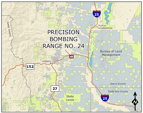
Deming Precision Bombing Range No. 24 Formerly Used Defense Site, or FUDS, consists of 960 acres in Sierra County, New Mexico. The site is located in southwestern New Mexico approximately 50 miles northeast of Deming and 25 miles southwest of Truth or Consequences.
In 1942, the War Department officially acquired the land to use as a precision bombing range. Pilots and bombardiers stationed at the Deming Army Air Field used the target for bombing practice between 1942 and 1944.
The practice bombing target range consisted of a day target, with a bull’s-eye surrounded by four concentric circles, and a night target, which was located to the west. A large oval track that served as a fire break encompassed the target. In 1945 the Army declared the range surplus to its needs and the land was transferred to the Department of the Interior in 1946.
Today, the majority of the former Deming PBR No. 24 is managed by the Bureau of Land Management, and the state of New Mexico owns a small portion along the eastern boundary of the property. The former Deming PBR No. 24 is used for cattle grazing, mining and recreational activities. There are active grazing leases and mining permits for and nearby the project area.
The U.S. Army Corps of Engineers began investigating the former bombing range in 1991 through the FUDS Program. Subsequent investigations identified munitions debris on the former range; however, further evaluations led the U.S. Army Corps of Engineers to determine that there was a very low potential hazard of someone encountering munitions hazards at the site. In the 2018 Decision Document, the No Further Action determination for the Deming Precision Bombing Range No. 24 was recorded.
An Administrative Record containing project documents and reports for Deming PBR No. 24 is available at the Truth or Consequences Library.